
Augmented Reality Landscaping: A Practical Guide
Discover how augmented reality landscaping transforms outdoor design. Learn tools, workflows, accuracy limits, and real-world applications
You're standing in a backyard that looks fine on paper but feels impossible to design. The fence is bare, the lawn slopes toward the patio, and a mature tree throws shade across the space. You can look at a plan or a catalog image, but you still can't tell whether a pergola will feel welcoming, oversized, or awkward beside the house.
Augmented reality landscaping helps close that imagination gap. Instead of showing a design in an abstract drawing, it places digital plants, paths, patios, walls, and structures into a live view of the actual property. That makes AR useful for exploring ideas, discussing alternatives, and building confidence before materials arrive. It also creates a risk that polished visuals can hide measurement problems, which is why AR should support professional verification rather than replace it.
Table of Contents
- What Augmented Reality Landscaping Actually Means
- How AR Landscaping Technology Works
- Practical Benefits for Homeowners and Professionals
- The Accuracy Question Most Guides Ignore
- Implementing AR in Your Outdoor Design Workflow
- Choosing the Right Tools and Platforms
- Where Augmented Reality Landscaping Is Heading Next
What Augmented Reality Landscaping Actually Means
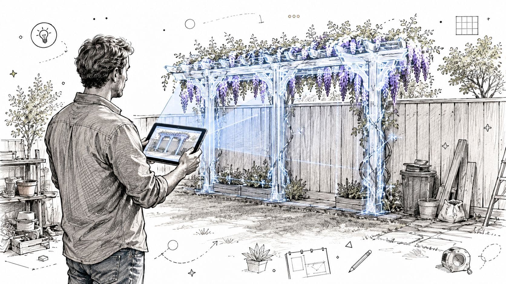
A homeowner might point a tablet toward an overgrown backyard and see a digital pergola appear along the fence. A planting bed can take shape beside the patio, while a small tree shows how the proposed layout might relate to the house, the existing lawn, and the neighboring property. The design isn't physically there. The device is combining its camera view with three-dimensional digital content anchored to the physical space.
That's the simplest definition of augmented reality landscaping. AR adds digital information to the world you're already looking at. Virtual reality, by contrast, places the user inside a fully digital environment and removes the live view of the yard. A clear guide to understanding AR and VR differences can help clarify why an AR site review feels different from walking through a VR model.
AR is more than a redesigned photograph
An AI photo redesign changes the appearance of a still image. It might add planting, furniture, a fire pit, or a new surface treatment to a picture of your yard. That can be a useful first step because it helps you compare styles quickly, but the result is still a visual concept contained within one photograph.
AR works in real time as you move the device. You can walk toward a proposed patio, view it from the side, or compare its relationship with a doorway and existing steps. The system tries to keep the digital model in place as the camera changes position, much like a transparent blueprint that remains attached to the ground.
The useful mental model
Think of AR as a conversation tool for space, not a construction document. It can answer questions such as:
- Would a tall planting group block the view from the kitchen?
- Does a curved path feel natural from the back door?
- Is the proposed seating area visually connected to the existing patio?
- Which of two layouts better fits the character of the house?
It can't automatically confirm property boundaries, drainage performance, structural requirements, utility locations, or buildable dimensions. Those questions still require site information and qualified judgment. AR's strongest contribution is helping people understand the design in context before they commit to detailed drawings, materials, and labor.
How AR Landscaping Technology Works
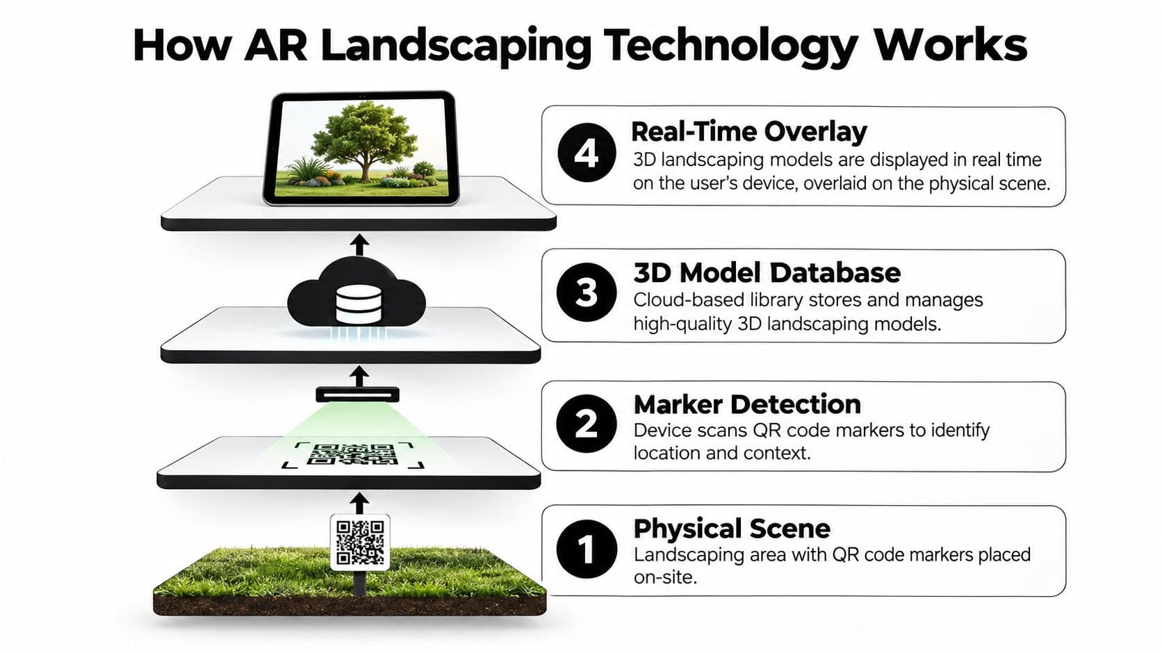
The screen looks simple, but several systems work together to keep a virtual tree or patio in a plausible position. The device captures the physical scene, estimates its own movement, receives or loads a three-dimensional model, and renders that model over the camera image.
The anchor determines how the design stays put
Marker-based AR uses a known physical reference, such as a printed target or a QR code mounted on a stake. The marker acts like a thumbtack. Once the device recognizes it, the software can place a digital bench, planter, or pergola in relation to that fixed point.
This method suits controlled demonstrations and smaller mockups. A contractor might place a reference target near a proposed patio corner, then show a client how the seating arrangement relates to that location. Because the system has a clear visual anchor, the experience can be stable when the camera remains within suitable viewing conditions.
Geospatial AR uses real-world coordinates and the device's sensors to position content across a broader property. GPS, accelerometers, cameras, and, on some devices, depth-sensing hardware contribute to the result. This approach is more suitable for exploring circulation, planting zones, or larger site concepts where placing physical markers everywhere would be impractical.
Architecture workflow research distinguishes these methods because they involve different field conditions and accuracy tradeoffs. Marker-based tracking is generally better for a focused, controlled presentation. Geospatial tracking supports site-wide exploration but can be affected by signal quality, tree canopy, and the complexity of the outdoor environment. Research on integrating AR into landscape workflows provides useful context for that distinction.
The model and the overlay
The software supplies a library of 3D objects, such as trees, shrubs, pavers, walls, lighting, or outdoor furniture. It then scales and renders those objects while the camera feed remains visible. Touch controls may let you rotate an item, move it, change its size, or swap it for another option.
Some platforms add AI-assisted recommendations based on an image, style preference, climate information, or available light. Treat these suggestions as design prompts. A generated planting idea still needs review for mature size, soil, exposure, irrigation, maintenance, and local suitability.
This short visual demonstration shows how a device can combine a physical site with a digital proposal:
For quick concept exploration, ai garden design software can help users develop visual directions from a garden image. That type of tool belongs alongside AR, not in the same category. A photo concept helps establish the look. An anchored AR model helps users judge the design while moving through the actual space.
Practical Benefits for Homeowners and Professionals
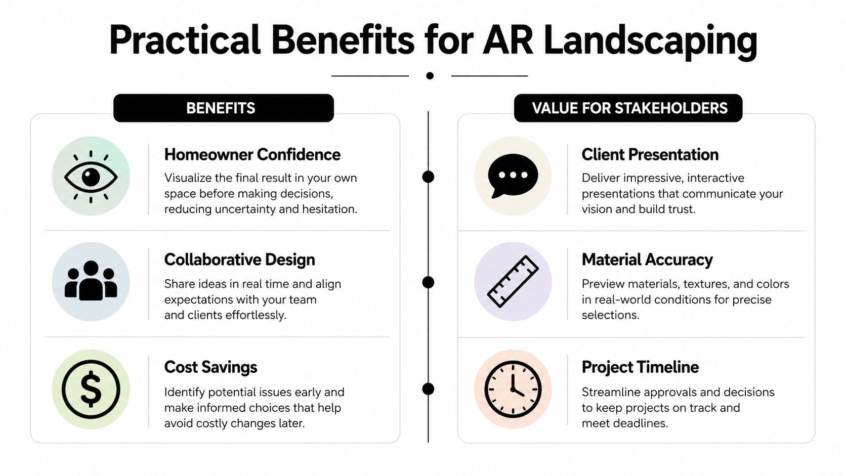
A homeowner may understand a plan on paper and still hesitate at the property. Seeing a proposed Japanese maple beside the entry, with shrubs and a path in view, turns an abstract drawing into a shared spatial reference. The main benefit is often confidence, not technical precision. AR helps answer, “Does this belong here?” before the conversation reaches detailed construction decisions.
AR also makes early revisions more interactive. A designer can switch gravel to flagstone, move a seating area, or compare different plant groupings while discussing the proposal. The design work remains, but clients can respond to visible relationships instead of trying to translate every change from a plan or PDF.
Where the conversation improves
Consider a contractor reviewing a backyard renovation with two homeowners. One wants a dining area near the kitchen. The other worries that the structure will make the yard feel closed in. A shared AR review can place the proposal beside the house, allowing both people to examine the same relationship from several positions. It works like a temporary full-scale sketch that can be moved while the design discussion is still open.
That approach can support:
- Client presentations: A contractor can show proposed walls, paving, planting, or structures on the actual property rather than relying only on a PDF.
- HOA discussions: A visual overlay can clarify the general location and appearance of a proposed feature, although formal submission requirements still apply.
- Irrigation conversations: A designer can show planting zones and discuss where water coverage may need to change. The overlay does not replace hydraulic design or field verification.
- Seasonal planning: A team can compare the intended character of a planting scheme across growth stages or seasonal appearances, provided the models represent those changes responsibly.
- Collaborative review: Homeowners, designers, and installers can identify disagreements earlier because they are discussing visible relationships rather than interpreting separate sketches.
Academic work on mobile AR in design describes the value of placing 3D proposals directly on real sites. Students using AR devices developed a better understanding of three-dimensional proposals, and the research identifies spatial awareness, design understanding, client communication, and collaborative evaluation as practical strengths. The design studio research is relevant to projects where scale, sightlines, and adjacency shape the decision.
The professional adoption signal
AR remains a specialized tool in the built environment, but professional interest is visible. An industry article citing Architizer's architectural visualization report says 21% of firms use AR for visualizations, while 31% plan to invest in AR within the next year. Those figures describe architecture firms, not every outdoor design business, so they should not be treated as a direct adoption rate. They do indicate that real-time visualization is becoming more useful for professional presentations.
For smaller contractors, the value depends on the sales process. A company proposing complex outdoor living projects may gain more from an on-site visual review than a business handling straightforward maintenance visits. AR earns its place when it improves a decision that would otherwise require repeated explanations, revisions, or uncertain interpretation.
Homeowners seeking quick visual exploration can also use backyard design ai to turn a property image into design concepts. That can help establish a direction before a consultation. It remains a concept tool, not a measured site plan, so survey information and contractor verification still govern construction decisions.
The Accuracy Question Most Guides Ignore
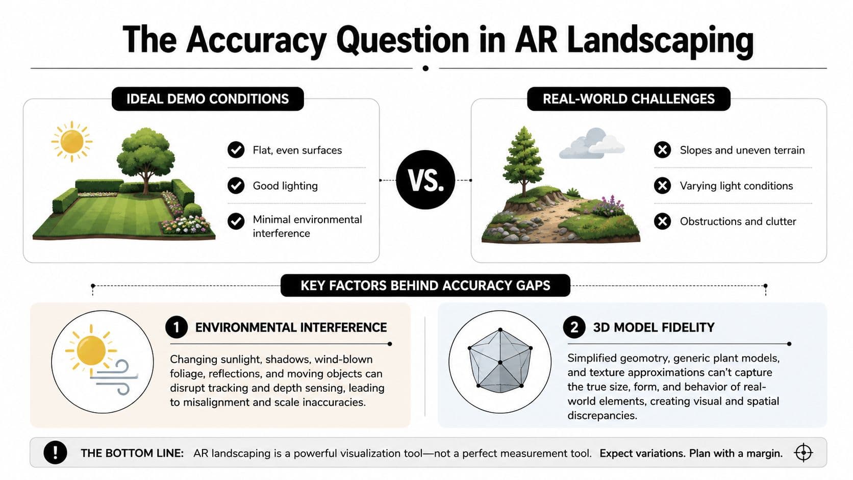
An AR demo often takes place under forgiving conditions. The lawn is open, lighting is even, the camera has a clear view, and the proposed object rests on fairly level ground. A real property may include slopes, shade, reflective surfaces, mature trees, uneven edges, old paving, and boundaries that have not been confirmed.
These conditions can make an overlay drift, float, sink, or look correctly placed from one viewpoint and less convincing from another. Geospatial systems may perform poorly when satellite positioning is weak or dense tree cover limits the device's view. Marker-based systems can hold position more reliably around a fixed target, yet they still require accurate placement and a suitable scanning angle.
Good enough for inspiration, not automatically for construction
A visual overlay can answer whether a pergola belongs near the fence or whether a planting bed should feel formal or loose. Those are visual and spatial decisions, so AR can give a client enough clarity to approve a direction.
Construction asks different questions. Exact grades, setbacks, drainage, footing locations, and material quantities depend on measured information. A patio that appears to fit on a phone screen may sit too close to a property line. A rendered retaining wall may look convincing while ignoring water movement or structural requirements. A path may appear level even though its actual grade would be uncomfortable or unsafe.
The distinction is similar to comparing a showroom mock-up with a set of construction drawings. One helps people judge the idea. The other gives the crew information they can set out and check.
Practical rule: Use AR to approve the idea. Use measured drawings and field checks to approve the build.
What verification still involves
Construction decisions may require a boundary survey, dependable site dimensions, elevations, a laser level, utility information, drainage analysis, or CAD documentation. Before ordering materials or setting work, the contractor should confirm critical dimensions on site.
The accuracy gap does not make AR unhelpful. It defines how the output should be described. Call it a concept, overlay, or visualization unless the site data and model have been checked to a construction-ready standard. AR can build confidence in a proposal, while confidence isn't the same as accuracy.
Implementing AR in Your Outdoor Design Workflow
Begin with the decision the visualization needs to support. A photo-based design tool can test broad styles from one yard image. An anchored AR session suits a client who needs to stand in the proposed space, compare sightlines, or see how a structure relates to the house. Choosing the right format prevents a polished image from carrying more authority than it deserves.
Start with a clean site record
Capture several useful viewpoints instead of relying on one dramatic angle. Include the house, fence lines, existing paving, mature trees, steps, and grade changes. Record conditions a camera may understate, including shade, standing water, low branches, and narrow access routes.
For an AR session, move the device slowly around the area and allow the software to recognize surfaces. Uneven ground, reflective objects, moving leaves, and low light can interfere with mapping. A rushed scan may produce an overlay that looks convincing from one position but shifts or behaves poorly as you move.
Build and review the concept
Load the selected 3D elements, then compare their scale with fixed features such as doors, windows, steps, and fence posts. Review major features from more than one position. A tree that suits the patio view may block the kitchen window.
Keep the first review focused on spatial decisions. Ask the client about circulation, enclosure, proportions, and relationships before discussing individual plant varieties. AR is most useful here as a shared reference, like placing a transparent model over the yard. It helps people judge the proposal, not certify its dimensions.
Turn the visual into instructions
The handoff requires more than screenshots. Export images or a shareable view for discussion, then convert the approved concept into information a contractor can price and build. That may include:
- Measured dimensions: Confirm lengths, widths, offsets, and elevations in the field.
- Material schedules: Identify paving, edging, walls, soil amendments, plants, and finishes.
- Construction drawings: Use CAD or another suitable drafting method where geometry and details matter.
- Site notes: Record drainage, access, utilities, existing conditions, and installation constraints.
- Verification points: Mark dimensions the installer must confirm before construction.
Use AR to make the proposal easier to understand and sell. Use field measurements, drawings, and contractor checks to determine whether the approved idea can be built safely and accurately. An attractive overlay can start the conversation, but it cannot supply every specification required for construction.
Choosing the Right Tools and Platforms
The right tool depends on whether you're exploring appearance or managing spatial decisions. Consumer AI apps generally begin with a photograph and generate a redesigned image. Professional AR platforms place adjustable 3D content into a live site view and may support model libraries, sharing, site tracking, or connections to other design workflows.
| Feature | Consumer AI Apps | Professional AR Platforms |
|---|---|---|
| Primary use | Fast style exploration from a yard photograph | Live, site-based review of 3D landscape proposals |
| Learning curve | Usually low, with guided prompts and simple controls | Higher, especially when models, anchors, and site data need preparation |
| Output | Rendered concepts or redesigned images | Interactive overlays viewed through a phone, tablet, or compatible headset |
| Accuracy | Visual interpretation of the uploaded image | Dependent on tracking method, device sensors, model scale, and site conditions |
| Best audience | Homeowners and designers testing directions | Contractors, landscape architects, and teams presenting or reviewing spatial proposals |
| Workflow fit | Easy to share for early discussion | More useful when the team needs repeatable presentations and documented handoffs |
| Construction readiness | Not a substitute for measured drawings | Still not a substitute unless the underlying data and specifications are verified |
A free or low-cost app can be sensible for a homeowner deciding between a cottage garden and a restrained modern scheme. It can also help a contractor start a conversation before investing time in a full proposal. Look closely at whether the tool preserves the actual structure of the property or merely produces an attractive reinterpretation.
Professionals should test the complete workflow, not just the demo. Check whether the platform supports the devices your staff already carry, whether models can be edited in the field, and whether outputs can be shared with clients and installers. Ask how it handles slopes, shade, repeat visits, and revisions.
For a broader starting point, this guide to the Best landscape design apps can help separate quick visual exploration from more involved planning tools. OutdoorBrite is one photo-based option. It lets users upload an image of a backyard, garden, patio, or front yard, choose a style, generate redesign concepts, and refine elements such as pergolas, fire pits, or planting beds. The result is useful for visual direction, while measured verification remains necessary for construction.
Where Augmented Reality Landscaping Is Heading Next
The next phase will connect AI, mobile sensing, and outdoor environment data in one workflow. A homeowner might explore a concept from a photo, place it on the property, and share the result with a designer who can develop it using more structured project information.
AI-assisted tools make early conversations easier. A homeowner can start with an existing image instead of a blank drawing. A designer can show several options for enclosure, planting character, circulation, or style before investing time in one detailed direction. The gain is faster discussion, not a replacement for professional judgment.
LiDAR-equipped phones and tablets may narrow the gap between casual visualization and spatial capture. They can add depth information, much like giving a sketch a rough sense of thickness and distance. A depth sensor still does not make a device a survey instrument. Property boundaries, legal setbacks, drainage, structural conditions, and construction tolerances require appropriate field methods and contractor verification.
Cloud-based environments may also improve coordination. A client in the office, a designer on the property, and an installer reviewing the proposal later could work from the same evolving model. Links to GIS, BIM, CAD, irrigation planning, and plant databases would give the visual layer useful context, especially on complex sites.
What deserves cautious optimism
Mobile-first tools are likely to gain ground because contractors and homeowners already understand the basic interaction. They can point, walk, compare, and share without a dedicated headset. That lowers adoption barriers, while leaving practical concerns such as staff training, device compatibility, setup time, and model accuracy.
Nursery catalogs and product libraries may add visual placement features, allowing users to compare plants and materials in context. The strongest platforms will connect inspiration to a disciplined handoff. An attractive overlay that cannot preserve scale, export useful information, or explain its limits remains a sales aid rather than a complete workflow.
The right investment depends on the repeated problem in your business. If clients struggle to understand proposals, AR may help them judge ideas before construction begins. If the bottleneck is grading accuracy or quantity takeoffs, improved surveying and documentation may provide more value.
AR will become one layer in a broader outdoor design process. It can inspire and help sell a direction when approximate placement is enough. Survey-grade measurements, specifications, and contractor checks still control the build when tolerances, drainage, boundaries, or quantities matter.
OutdoorBrite lets you upload a photo of your actual yard and generate redesign concepts, then refine planting beds, pergolas, and fire pits before meeting a contractor. Visit OutdoorBrite to explore an early direction, compare options, and bring a clearer visual brief to your next landscaping conversation.
See your yard reimagined
Start creating